
This page has been archived and is being provided for reference purposes only. The page is no longer being updated, and therefore, links on the page may be invalid.
|
|
|
|
Using Remote Sensing to Map Soil Salinity on a Regional Scale
By Ann PerryJune 29, 2010
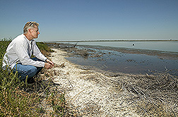
An Agricultural Research Service (ARS) scientist has led efforts to develop a new method for using remote sensing to assess soil salinity. This could give land managers worldwide a regional-scale tool for measuring and inventorying soil salinity in fields where salt buildup lowers crop yields.
ARS soil scientist Dennis Corwin led a team that used Moderate Resolution Imaging Spectroradiometer (MODIS) imagery to assess and map soil salinity across approximately 741,300 acres of North Dakota's and Minnesota's Red River Valley. Increased soil salinity levels in this region have been linked to higher water tables caused by management and precipitation changes over the past 20 years.
The team compared two vegetation indices: the normalized difference vegetation index (NDVI) and the enhanced vegetation index (EVI). Both indices were developed using seven years of vegetation reflectance data obtained with MODIS imagery. The team also collected soil samples from 60 fields across three counties in the Red River Valley to see how strongly field-scale soil saline levels correlated with the EVI and NDVI indices.
The researchers found that 21 to 37 percent of the variability in soil salinity levels could be correlated with EVI. Then they added another factor into their estimates: whether the land qualified for the Conservation Reserve Program (CRP), a federal program that sets aside marginally productive land for conservation purposes. They found that 34 to 53 percent of the variability in soil salinity could be correlated to EVI and whether land was eligible for CRP inclusion.
For this project, Corwin partnered with Stanford University scientist David Lobell and former University of California-Riverside statistician Scott Lesch. Corwin is at the U.S. Salinity Laboratory in Riverside, Calif. Other collaborators included Michael Ulmer, Keith Anderson, Dave Potts, James Doolittle, Manuel Matos and Matthew Baltes, who are soil scientists with the U.S. Department of Agriculture (USDA) Natural Resources Conservation Service (NRCS).
Results from this research, which were published in the Journal of Environmental Quality, provide the NRCS with an easy and reliable tool for mapping soil salinity over regions that span from hundreds of thousands to millions of acres.
ARS is USDA's principal intramural scientific research agency. The research supports the USDA priority of ensuring international food security.