
Link to RISE
|
Research Insights in Semiarid Ecosystems (RISE) is a symposium featuring invited speakers presenting recent or on-going research on the WGEW, the SRER or other outdoor laboratories in the region. There will be time for questions from the audience, which will consist of federal agency, NGOs (non-governmental organizations) stakeholders from southern Arizona and university faculty, staff and students.
|
Link to FindACollaborative.org
|
Find a Collaborative is a discovery tool for the Collaborative Conservation Mapping Project. The purpose of the Collaborative Conservation Mapping Project is to inventory and map collaborative groups and support organizations/entities working on conservation and resource management in the Southwest and Rocky Mountain regions. We help collaborative groups and support organizations more easily find and connect with each other for shared learning and problem solving.
|
|

Link to Cienega Timeline Project
|
The Cienega Watershed Timeline traces the Cienega Watershed history through interactive features that allow you to explore specific events and periods of time for this important watershed in Southeastern Arizona. Searchable categories include local history and prehistory, fauna, flora, land uses, land forms, policies and legislation, climate and weather, and water along with people and cultures that have contributed to the watershed history. At the bottom of the timeline for those periods in which climate data is available (1896 to 2016), you will find climate information displayed for each year that you select.
|
|
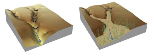
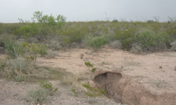
Link to Rangeland Restoration Research Story Map
|
Rock check dams are used throughout the world to mitigate erosion problems on degraded lands. Small rock dams have been used for centuries to alter runoff and sediment. Today, rock check dams are being used in rangeland restoration projects throughout the southwestern US.
This is a story map on the impact of rock check dams in southern Arizona, with a photo and publication archive.
|
|

Link to Communicating Rain Importance to 3 Audiences Visualization
|
Rainfall, runoff and other hydroclimatic and ecological variables have been measured at the Walnut Gulch Experimental Watershed (WGEW) since the 1950s. These data have been used to advance scientific understanding of dryland hydrology; inform policy decisions; provide tools and resources lo producers and land managers; and served as an educational resource for students. This case study examines three different ways to present rainfall and vegetative data to three distinct audiences. Each dashboard has been tailored to suit the different needs of each audience.
|
|
Link to SWRC Timelapse Videos
|
A series of timelapse videos recorded by SWRC scientists on the following areas:
- Riparian Grazing
- Erosion Processes
- Hydrologic Processes
- Rainfall Simulation Experiments
|

