
| The Agricultural Conservation Planning Framework |

|
ACPF - Watershed Management Tools
The Midwest is made up of thousands of small watersheds, each containing thousands of acres of agricultural land. This intense concentration of agriculture has negative impacts on soil health and downstream water quality from nutrient transport. The Agricultural Conservation Planning Framework (ACPF) provides a watershed approach and set of GIS tools designed to find conservation opportunities across different landscapes.
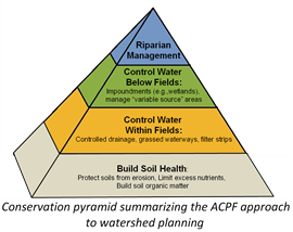
The ACPF is based around a holistic approach emphasizing the importance of building soil health through practices such as minimal tillage and cover crops, which could be applied to any agricultural field. The framework is then built upon by locating suitable sites for conservation practices by applying GIS to elevation, soils, and land use data. The practices sited include grass waterways, contour buffer strips, nutrient removal wetlands, denitrifying bioreactors, and others. They are designed to intercept flow (overland or tile drained) to either decrease erosion potential or increase retention time allowing denitrification.

Once the GIS tools have been completed for a watershed, a menu of conservation opportunities found in fields, below fields, and along riparian zones are available. Along with the location of practices, each output contains information on the amount of water a practice would intercept or store, and amount of land the practice would take out of production. Conservationists, watershed planners, and land owners now have the resources to develop a preferred watershed plan for their own landscape and farm. They can also become more engaged with how the practices function and where a practice may be most effective within a watershed based on the amount of water it intercepts.
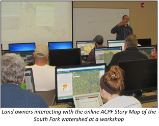
There have been efforts to disperse information from the ACPF and gauge its community reception. A group of researchers out of Purdue University have completed interviews from six watersheds between Minnesota and Iowa to understand why and how planners may be using the ACPF. A team at the National Lab for Agriculture and the Environment has also been working to distribute the results through online Story Maps by ESRI to allow people to view their conservation options on their own time.