
This page has been archived and is being provided for reference purposes only. The page is no longer being updated, and therefore, links on the page may be invalid.
| Clark Animal Tracking System |

|
This is not a commercial site nor do we sell animal tracking systems. Information contained on the site is designed to help others build their own animal tracking systems from off-the-shelf components.
Satellite Communications GPS collar **(NEW)**
As an improvement on this, our original animal tracking system, we have also recently developed a new GPS/Satellite Communications-based tracking collar system utilizing a satellite data modem to link to the collar remotely. Data and programming can be transferred to and from the collar via email transactions through the satellite communications (sat phone) system. The satellite link provides truly global, 24/7 accessibility to deployed collar data. In May 2007, for example, we used the satellite link to send real-time GPS locations from collars deployed in the Eastern Gobi of Mongolia to email addresses we accessed here in Boise, Idaho, USA. In addition to increasing data accessibility, the satellite link also allows the user to revitalize malfunctioning collars by uploading new or corrected programming. This new Sat Comm/GPS tracking system has lower operational costs and much greater data through-put than traditional (ARGOS) satellite links. For more information contact Pat Clark.
 Overview
An improved GPS-based animal tracking system is needed to meet quickly-evolving demands of ecological research, range livestock production, and natural resource management. The Clark GPS Animal Tracking System (Clark ATS) was developed by our research team as a tool to further our ecological research and meet the needs of other researchers, resource managers, and livestock producers. Our objectives were to develop a low-cost, GPS-based animal tracking system with the following capabilities:
- Large and easily expandable on-collar data storage capacity••
- spread-spectrum radio frequency (RF) link enabling data downloading and program uploading between collars and basestations
- low-power hardware components, software-controlled power management and high power-density batteries to enable long deployments
- real-time collar tracking capabilities where the GPS data describing the current location of the collar are transmitted via the RF link to a hand-held basestation capable of receiving and displaying collar locations on a digital map.
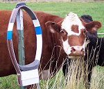
The Clark ATS consists of a GPS tracking collar and a basestation (fixed or mobile hand-held). The tracking collar collects and stores GPS fix information including collar location (Lat/Long), date and time (Greenwich Mean), and parameters indicating fix quality (e.g., dilution of precision and number satellites used) on a removable memory card (CompactFlash?) contained within the collar. Raw satellite data (e.g., carrier phase, pseudorange, and Doppler measurements) acquired and used by the GPS receiver to calculate a GPS fix are also stored on the memory card allowing post-differential correction of the GPS locations for improved spatial accuracy. Use of the removable memory card for data storage allows the user to quickly remove data from the collar while still in the field. Changing the data storage capacity (e.g., 16 MB up to 8 GB) of the collars for different applications is as simple as inserting a memory card with a different capacity.
The collar and basestation units are wirelessly linked by radio transceivers. These radios operate in the spread spectrum radio bandwidth (902-928 MHz). Spread spectrum radios can frequency-hop throughout this wide bandwidth looking for an unused frequency for data transmission (Ziemer et al. 1995). Frequency-hopping helps maximize successful and timely data transmissions and eliminates conflicts even when many different users are in the same coverage area.
Besides collecting and storing raw GPS fix information described above, the collar also collects and transmits Wide Area Augmentation System (WAAS)-corrected GPS fix data to the basestation via the radio link. In the way, the collar is transmitting a GPS location beacon to any basestation within range allowing real-time tracking of the collar location. Collar location data received by the basestation are stored in an electronic data base on the basestation for later use. These location data may also be plotted in real-time on digital topography maps and orthophotographic images using basestation software. The radio transceivers also make it possible to remotely download data stored on the collars and to remotely upload new programming to the collar from the basestation.
Build your own animal tracking system
Background
Study of animal behavior and demography using telemetry tracking systems began in the late 1950s and early 1960s (Le Munyan et al. 1959; Eliassen 1960; Marshall et al. 1962; Cochran and Lord 1963; Mech et al. 1965). Collars or tags emitting very high frequency (VHF) radio signal pulses allowed animal ethologists, wildlife biologists, and range scientists to track and monitor animal behavior, survival rates, and other parameters. Intensive monitoring of widely-roaming animals, however, was costly, time-consuming, and posed risks to personnel safety. Additionally, the spatial or positional accuracy of radio-location data was strongly tied to the effort and expense applied during data collection. With the launch of the NIMBUS 3 satellite (Kenward 1987) and, later, the Argos system (Fancy et al. 1988), it became possible to automatically collect and/or transmit location data from widely-roaming or migrating animals (e.g., polar bear and caribou) using satellite communication technology (for examples see White and Garrott 1990). The positional accuracy of these location data, however, was quite coarse (? 300 m) (Britten et al. 1999) thus negating their use for habitat selection studies. Deployment of the NAVSTAR Geographic Positioning System (GPS), declared fully operational in 1995, enabled development of animal tracking systems with unprecedented positional accuracy (? 5 m) (e.g., Rodgers et al. 1996). These GPS-based tracking systems allowed evaluation of animal movement and behavior at very fine spatial resolutions (e.g., habitat selection at the feeding-station scale).
Despite these technological advances, telemetry tracking systems have not kept pace with the evolving demands of ecological research. Costs of commercial GPS tracking collars severely limit the sample size (i.e., individual animals) and statistical power that researchers have available for animal behavior and ecology studies. Commercial GPS collars also have data storage constraints that hinder collecting location data with high-temporal frequency (e.g., every 1-5 minutes or less) over long deployment periods (up to 1 year of more). Consequently, intensive investigations of habitat selection, short- and long-range movements, and other animal behaviors cannot be conducted over multiple seasons or years without frequently down-loading and erasing data from the collar memory. Some commercial systems have remote data-download capabilities, reducing the need to frequently recapture collared animals for data retrieval. These systems, however, download data via satellite (e.g., Schwartz and Arthur 1999), GSM (Global System for Mobile communications) cellular telephone, or telemetry radio frequencies (Rodgers et al. 1996). Satellite communication is excessively expensive. The GSM cellular coverage in the wildlands of North America is extremely limited. Radio-based systems utilize narrow-band VHF or UHF (ultra high frequency) requiring the user to obtain frequency allocations which dictate where and when these systems can be used. None of these existing systems were designed to provide continuous, real-time data access which is currently needed by ecologists, animal ethologists, and other researchers.
Collar Components
Major components of the GPS telemetry collar include a single-board computer with a CompactFlash? card slot, a GPS receiver, an active GPS patch antenna, a spread spectrum radio transceiver, and an omni-directional radio antenna. The collar is powered by either one or two high-capacity Tadiran D-cell battery depending on the planned length of deployment and weight considerations. Other collar components include a printed circuit board (PCB), a back-up battery, a regulator, capacitors, resistors, and various electrical connectors. A bill of materials (BOM) list for the components and materials needed to construct the collar is available.
Mobile Basestation Components
Major components of the hand-held mobile basestation include a Pocket-PC personal digital assistant (PDA), spread spectrum radio transceiver, omni-directional antenna, waterproof PDA case. The radio and PDA components of the basestation were each powered by separate rechargeable battery packs carried outside the PDA case in a beltpack or backpack. Other basestation components included a level-shifter, regulator, rocker switch, antenna-adapter cable, PDA synchronization/serial adaptor cable, capacitors, and resistors. As with the collar, a bill of materials for the mobile basestation is available.
Detailed, step-by-step instructions for purchasing materials, constructing collars and basestations, and programming and testing the Clark ATS are provided on this site.
Build your own animal tracking system
There are no restrictions on the use of the information to build and deploy the Clark GPS collars. There are also no warranties.
Mention of manufacturer, trademark name or proprietary product does not constitute endorsement by the USDA, Oregon State University, or Boise State University and does not imply their approval to the exclusion of other products that may also be suitable.