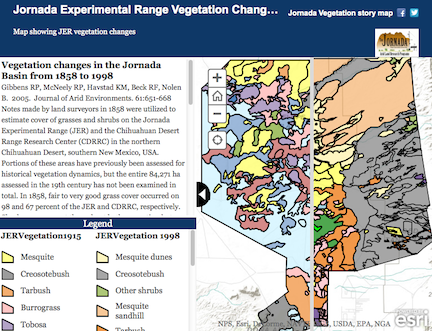
Vegetation Maps published in the Journal of Arid Environments:- Jornada Experimental Range and Chihuahuan Desert Rangeland Research Center Grass Cover 1858 (113 KB) - 8.5"x11"
- Jornada Experimental Range and Chihuahuan Desert Rangeland Research Center Shrub Presence 1858 (298 KB) - 8.5"x11"
- Chihuahuan Desert Rangeland Research Center Vegetation Types 1938, 1998 (492 KB) - 8.5"x11"
| 
Desert Soils Project, Volume III:- Map 1: Topography, Soil Parent Materials, and General Climatic Zones (2,848 KB) - 11"x17"
- Map 2: The Jornada and Mesilla Basins (159 KB) - 11"x17"
- Map 3: The Soil Chronology (2,233 KB) - 11"x17"
- Map 4: Carbonate Stage (2,467 KB) - 11"x17"
- Map 5: The Mollic Epipedon and Its Analog (1,761 KB) - 11"x17"
- Map 6: The Argillic Horizon (1,898 KB) - 11"x17"
- Map 7: The Argillic Horizon and Dominant Carbonate Stage (2,072 KB) - 11"x17"
- Map 8: General Soil Map (3,121 KB) - 11"x17"
- Map 9: Soil Geomorphic Reconstruction: The Soil Chronology at the End of the Pleistocene Full-Glacial, 17,000 Years Ago (1,972 KB) - 11"x17"
- Map 10: Soil-Geomorphic Reconstruction: The Argillic Horizon at the End of the Last Pliestocene Full Glacial, 17,000 Years Ago (1,853 KB) - 11"x17"
- Map 11: Soil-Geomorphic Reconstruction: The Stage of Carbonate Accumulation at the End of the Last Pleistocene Full-Glacial, 17,000 Years Ago (2,803 KB) - 11"x17"
- Map 12: Constructional Surfaces vs. Structural Benches (549 KB) - 11"x17"
- Map 13: The Jornada Surface, Deposits of the Ancestral Rio Grande, and Intervening Buried Soils South of Highway 70 (2,262 KB) - 11"x17"
- Map 14: Coppice Dunes (1,944 KB) - 11"x17"
- Sheet 1: The Desert Soil-Geomorphology Project (7,726 KB) - 34"x44"
- Sheet 2: Chronology of the Desert Project and Vicinity (2,799 KB) - 34"x44"
- Sheet 3: Illustrated Morphological Features (9,200 KB) - 34"x44"
- Sheet 4: Some Effects of Human Activities on Eolian Erosion and Deposition: Historical Coppice Dunes (13,005 KB) - 34"x44"
- Sheet 5: Soil-Geomorphic Reconstruction: The Soil Chronology, Argillic Horizon, and Stages of Carbonate Accumulation at the End of the Last Pleistocene Full-Glacial, 17,000 Years Ago (7,793 KB) - 34"x44"
- Sheet 6: Soil-Geomorphic Reconstruction: The Jornada I Surface (Estimated Age: 250,000 to 400,000 Years), Deposits of the Ancestral Rio Grande, and Intervening Buried Soils South of Highway 70 (3,698 KB) - 36"x39.5"
- Sheet 7: The Detailed Soil Map at Reduced Scale (6,052 KB) - 36"x45"
|