
| Potential United States Range Expansion of the Invasive Fire Ant |

|
Map Links
Potential United Sates Range Expansion of the Invasive Fire Ant
Arizona | Arkansas | California | Hawaii | Maryland | Nevada
New Mexico | North Carolina | Oklahoma | Oregon | Tennessee
Texas | Virginia | Washington
State Maps
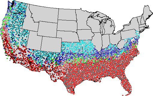
 This map predicts areas in the United States that are susceptible to invasion by the red imported fire ant, Solenopsis invicta. Predictions are based on climate and current northernmost distributions of red imported fire ants. To generate these predictions, a dynamic model of colony growth was developed which depended on daily maximum and minimum soil temperatures. Temperature records at 4,537 meteorological stations within the current and potential range of S. invicta were obtained from NOAA's National Climatic Data Center. At each station, a colony was allowed to grow and reproduce. The map of reproducing colonies was then compared with the current fire ant distribution. After calibration to the current northernmost extremes in Arkansas, Tennessee, and Oklahoma, four zones of colony success were defined: certain, possible, undemonstrated, and improbable. An annual precipitation limit was selected to indicate regions where arid conditions may prohibit growth in non-irrigated areas. Results of the model predict that red imported fire ants will likely move 50-100 miles north in Oklahoma and Arkansas. They will also likely continue expanding into portions of Virginia, Maryland, and Delaware in the east and New Mexico, Arizona, California, Oregon, Nevada, and maybe even Washington and Utah in the west.
This study was a joint project of the University of Arkansas at Monticello and the USDA-ARS lab here in Gainesville, Florida. For more information see:
Korzukhin, M. D., S. D. Porter, L. C. Thompson, and S. Wiley. 2001. Modeling Temperature-Dependent Range Limits for the Red Imported Fire Ant (Hymenoptera: Formicidae: Solenopsis invicta) in the United States. Environ. Entomol. 30: 645-655. 
The Hawaiian map was provided by M. Korzukhin and E.VanGelder, USGS/BRD, Haleakala Field Station, Makawao, Hawaii.