| Evaluation of Agricultural Retention and Processing in a Large Forested Wetland/Riparian Zone in the Mississippi Delta MSEA: Shallow Ground Water |

|
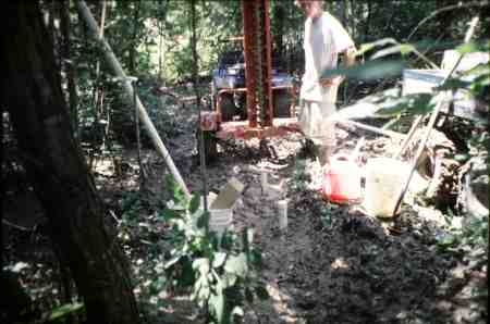
Project Statement:Recent aquifer surveys evaluating agricultural pollution impacts detected varying levels of 46 different pesticides in the groundwater of 26 states.The extent and infiltration rate of these pesticides moving from field to groundwater depends on a number of variables (i.e. farm chemical and soil management practices, soil and field characteristics, and depth to water table). Agrichemical management strategies for many new short-lived pesticides seek to promote complete degradation by keeping contaminated runoff near the soil surface and point of origin. Practices and features designed to slow runoff and enhance degradation between field and waterway include no-till and reduced-till farming, grass filter strips at field?s edge, vegetated drainage ditches, natural and constructed wetlands, and riparian zones. Benefits of riparian zones as sediment filters have long been acknowledged with most recent riparian studies focusing on wildlife usage and optimum zone widths. Few studies have dealt with understanding the actual trapping, leaching, and transformation processes occurring in these riparian areas. The current project will monitor shallow groundwater in a 200+ acre riparian zone in the larger framework of the MSEA (Management Systems Evaluation Area) project in the intensively farmed Mississippi delta. Monitoring/sampling will be accomplished using a series of at least 3 shallow wells per site (5, 10, and 15 depths) at 7 sites throughout the riparian zone. The lead collaborator on this project is Mr. Sammie Smith at the National Sedimentation Laboratory (Agricultural Research Service). The Wetland Science Institute of the Natural Resources Conservation Service sponsors this project. Progress Statement:Three sites (nine wells) have been installed. The remaining four sites will be installed when the drill rig is available and weather permits access. Additional plans call for installation as soon as possible of a fourth well (2? depth) at each site for stage measurements. About a dozen samples have been pulled and are awaiting analysis. |