

 Image Number D3367-1 |
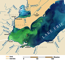
A satellite image of Lake Erie from September 2011, overlaid on a map of the lake and its tributaries. This image shows the algal bloom (green) covering the entire western basin and beginning to expand into the central basin. ARS scientists are monitoring phosphorus discharge from farms in surface runoff and tile drainage, so they can recommend best management practices to farmers.
Photo by Michigan Sea Grant.