
This page has been archived and is being provided for reference purposes only. The page is no longer being updated, and therefore, links on the page may be invalid.
|
|
|
|
Water Quality Model Passes Another Test
By Don ComisFebruary 24 , 2010
A test of the SWAT (Soil and Water Assessment Tool) model on a small watershed with poor water quality in Maryland showed that the model accurately estimated pollutant levels on an annual basis, according to Agricultural Research Service (ARS) scientists and their University of Maryland cooperators.
Water resources engineer Aisha Sexton and soil scientist Ali Sadeghi, at the ARS Hydrology and Remote Sensing Laboratory in Beltsville, Md., worked with watershed hydrologic and water quality modeler Adel Shirmohammadi, at the University of Maryland, College Park, on an 11-year study of the Warner Creek watershed in Frederick County, Md
Shirmohammadi and Hubert Montas, professor and associate professor, respectively, in bioenvironmental and water resources engineering at the University of Maryland, also worked with several graduate students and post-doctoral researchers at the University, particularly during the first seven years of the study. The U.S. Environmental Protection Agency provided the major funding for this project with a grant authorized by Section 319 of the Clean Water Act, which addresses non-point sources of water pollution. ARS provided supplemental funding.
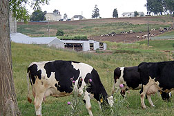
This approximately one-square-mile watershed drains into a tributary of the Monocacy River. High levels of nitrogen and phosphorus flow from the 966-square-mile Monocacy River Basin into the Chesapeake Bay, mostly from cattle manure and crop fertilizers. The Warner Creek watershed is a mix of farm, forest, and urban lands.
Shirmohammadi, Sexton, Sadeghi, and other colleagues in the project found the SWAT model to be satisfactory on an annual basis in mixed land use watersheds in the Piedmont physiographic region studied, and thus suitable for use in EPA's "Total Maximum Daily Load(TMDL)" program. This program sets limits on water pollutants such as silt, nitrogen, phosphorus, pesticides, mercury and bacteria for about 40,000 bodies of water that EPA has found to have poor water quality.
A team of ARS agricultural engineers in Temple, Texas, led by Jeff Arnold,developed the SWAT model in the early 1990s.
ARS is the principal intramural scientific research agency in the U.S. Department of Agriculture.