
This page has been archived and is being provided for reference purposes only. The page is no longer being updated, and therefore, links on the page may be invalid.
|
|
|
|
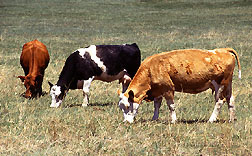
Heat Stress Model Keeps Cows Cool
By Laura McGinnisMarch 17, 2008
It's hard to relax if your cattle are stressed, so the ability to predict and avoid potential stressors is essential.
Fortunately, an online model developed by scientists with the Agricultural Research Service (ARS) provides information to help cattle—and producers—keep their cool when temperatures rise. ARS is the U.S. Department of Agriculture's chief scientific research agency.
For years, producers relied on the National Weather Service for livestock weather warnings. When that service was discontinued in the mid-1990s, many producers turned to university websites. The university warnings, like those they'd replaced, were based on temperature and humidity predictions, but did not account for other influential factors.
Elevated temperature is obviously the driving force behind dangerous heat levels, but other parameters—such as humidity, sun intensity and wind speed—are influential as well. The ARS model, developed by Tami M. Brown-Brandl and Roger Eigenberg at the agency's Roman L. Hruska U.S. Meat Animal Research Center in Clay Center, Neb., considers all four parameters in its calculations.
The model, which is updated twice daily, makes predictions for South Dakota, Nebraska, Iowa, Kansas, Missouri, Oklahoma, western Colorado and northern Texas. It analyzes weather forecast information, assesses the danger of incurring heat stress and displays that information as a color-coded map.
Ranchers and other cattle managers can consult the map to gauge the heat threat level in their region. More than 200 visitors used this site during the critical heat stress months of July and August in 2007.