United States Department of Agriculture
AgResearch Magazine


Forum—Managing Land with Aerial Digital Cameras
|
|
Imagine taking a ride in a small plane or helicopter that’s flying as low as possible while trying to keep your binoculars on one geographic feature. Try to stay focused on that feature while you experience the roll, pitch, and yaw of the aircraft as it is buffeted by winds and while atmospheric haze blocks your view.
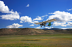
That’s what can sometimes make aerial photography and imaging more challenging than collecting data from ground instruments or from satellites flying above the atmosphere. But very-high-resolution aerial photography with digital cameras aboard low-flying ultralight aircraft and unmanned aerial vehicles (UAVs) has evolved into another important tool for remote sensing of natural resources.
This has come about in part because of the shift towards research focused on entire landscapes and watersheds instead of on isolated portions. It is also made possible by rapidly advancing technologies, starting with increasingly smaller digital cameras and specialized spectral sensors. The cameras offer lightweight, instant-image alternatives to the bulky large-format film cameras traditionally used for aerial photography.
The revolution in camera technology even affects ground monitoring, as described in the article "Rangelands Are Ready for Their Close-Up" on landscape panoramas in this issue.
Digital aerial photography has become an integral part of rangeland monitoring. The imagery has many other uses, such as monitoring alterations of forests and other vegetation caused by human activities like farming, gas and oil exploration, and urbanization. The need for monitoring land-use changes is nationwide.
Digital aerial imagery is an adjunct to satellite imagery, ground-level imagery, and ground sampling. There is a time and place for each, and often one is used in combination with others. Ground sampling has to be done coincident with aerial or satellite imaging. Being able to tie ground-based samples to image information enables greater use of imagery and reduces the frequency of ground sampling—a major goal of remote-sensing research. Aerial imagery is also less expensive than intensive ground sampling, thus enabling more frequent landscape surveys. Doing surveys on a consistent basis allows scientists to identify trends in landscape changes and relate these changes to consequences of management actions.
Aerial photography, especially from 300 to 700 feet above the surface, provides more detail than satellite imagery taken from 3,000 to 6,000 miles in space. It is this greater level of detail that makes low-level aerial imagery ideally suited for land-management decisions. The imagery is proving useful for monitoring crop fields, rangelands, forests, streambanks, wetlands, and wilderness areas. But experience has shown that we need a range of resolutions and detail, depending on the use of the imagery. These uses include taking field and regional looks at winter cover crops to measure crop intake of nitrogen to keep it out of waterways; identifying plant species on western rangelands; and directing pesticide spray from “crop duster” airplanes. Even within aerial imagery, there are different tools for different purposes. Cameras and sensors mounted on model airplanes, UAVs, and ultralight aircraft bridge the gap between ground sampling and imaging from higher altitudes via airplanes or satellites.
Right now, we have to fly low and slow when very high resolutions are needed, but quickening the shutter speed of a telephoto lens is one way to increase the resolution from higher altitudes without further reductions in speed. The story on "Photographing Land Changes From Low in the Sky" in this issue discusses this technology.
A researcher with the Agricultural Research Service in Beltsville, Maryland, invented a way to convert a common digital camera so that it can take infrared aerial images for land-use monitoring and plant-nutrient condition assessments. ARS patented the invention jointly with David Linden, who is currently at Science Applications International Corporation, headquartered in McLean, Virgina. The exchange of ideas between scientists from different parts of the country, as shown in this article, illustrates the advantages of having ARS locations nationwide, and working with other agencies, industries, and universities.
There is a saying in management that you can’t manage what you can’t measure. Aerial imagery and the continuously evolving technologies of remote sensing offer affordable ways to measure. Imagery also helps adaptive management by providing feedback on a regular basis, so that management changes can be made quickly in response to the feedback.
Information from airborne and spaceborne imagers can also help us understand ecological interrelationships to better manage natural resources. Soil, water, forests, crops, and wildlife are intertwined such that a management change in one area can affect others. Information from imagery coupled with ground-based research of landscapes enables producers and land managers to maintain productive yields while safeguarding other valued products and services of our landscapes and watersheds.
Charles L. Walthall
ARS National Program Leader
Climate Change, Soils, and Emissions
Beltsville, Maryland
"Forum" was published in the September 2011 issue of Agricultural Research magazine.