
This page has been archived and is being provided for reference purposes only. The page is no longer being updated, and therefore, links on the page may be invalid.
Read the magazine story to find out more. |
|
|
Estimating Crop Residue from Space via Satellite
By Don ComisApril 2, 2009
How much of America’s croplands are being farmed using conservation tillage? Agricultural Research Service (ARS) scientists are developing techniques to use satellites to answer that question.
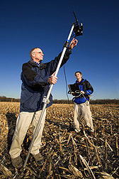
The ARS scientists—research agronomist Craig Daughtry and agricultural meteorologist Paul Doraiswamy—are also studying satellite sensors and geographic information systems (GIS) technology to identify farm fields that can sustain more residue removal for ethanol production without harm to the soil. Daughtry and Doraiswamy work at the ARS Hydrology and Remote Sensing Laboratory in Beltsville, Md.
Conservation tillage leaves enough crop residue to cover at least one-third of the soil, while conventional tillage leaves the soil nearly bare.
Currently, methods for estimating tillage intensity based on crop residue cover are time-consuming. The private Conservation Technology Information Center does its estimates by driving around farmland in each county and stopping every mile for a look. USDA’s Natural Resources Conservation Service (NRCS) estimates residue cover by placing a transect line with evenly spaced beads across crop rows and counting the number of beads hitting residue.
Each spring, the ARS researchers go to Midwestern corn and soybean fields—and Maryland’s Eastern Shore—to check residue levels and compare their estimates to infrared digital pictures taken by experimental satellites and to hyperspectral images taken from aircraft. Last year, they added fall measurements to see how much residue could safely be removed to make ethanol and maintain adequate residue cover for soil conservation.
Daughtry and his colleagues are working with the National Aeronautics and Space Administration to develop an accurate measurement method for use by NRCS.
Read more about this research in the April 2009 issue of Agricultural Research magazine.
ARS is the principal intramural scientific research agency in U.S. Department of Agriculture.